Watershed Surveys
Pocasset watershed survey staff and volunteers, Sept 2023
What is a Watershed Survey?
30 Mile works with Maine DEP, local partners, and trained volunteers to survey the watershed of each lake or pond to identify sources of erosion and runoff that could harm water quality. Watershed Surveys raise public awareness of watershed issues, the need for watershed protection, and the local stakeholders involved in lake protection, Watershed surveys also identify current erosion problems, the locations of these sites, and how severe the impact to water quality may be. Survey data is used to inform watershed planning efforts, provide cost-effective solutions for landowners, and to pursue grant funding for high-cost sites.
Soil erosion is the #1 threat to our lakes
Soil particles carry phosphorous – a nutrient that algae use to grow. Soil carried in stormwater runoff deposits phosphorus into nearby streams and lakes, where it is taken up by algae. Erosion problems anywhere within a watershed, even miles away, can affect the lake.
What is a watershed?
A watershed includes all the land that drains to a lake through streams, ditches, directly over the ground’s surface, or through groundwater. Even though a watershed may extend many miles away from the lake itself, it is actually part of the lake ecosystem. Lake water quality is a reflection of the surrounding watershed. A healthy watershed means a healthy lake!
NEW: 2023 Pocasset Lake Watershed Survey Report!
Click Here or Scroll Down
2023 Pocasset Lake Watershed Survey Report now available!
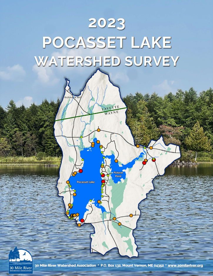
On September 28th, we completed the Pocasset Lake Watershed Survey. Fourteen volunteers led by six technical leaders worked together for a full day of fieldwork, traveling throughout the entire watershed looking for erosion problems that threaten water quality. 69 erosion sites were identified, and a full report of our findings, recommendations, and prioritized next steps will be available this winter. Follow-up letters will be sent to all landowners with identified erosion sites.
THANK YOU to the watershed landowners who cooperated and participated in the survey, A special THANKS to the survey volunteers who dedicated much time to this effort: Marianne Butak, Fred Duplisea, Desi Fyler, Mary Ann Hayes, Cynthia Giguere-Unrein, Sue Heard, Lloyd Irland, Andrew Kittel, Kelly Kittel, Patt Koscinski, David Randall, Jeremy Smith, Dick Windecker, and Patti Windecker.
The survey was organized and facilitated by 30 Mile staff with support from the Pocasset Lake Association (PLA), Maine DEP, and the Town of Wayne, and with financial assistance through a grant from the Davis Conservation Foundation.
Key Survey Findings:
Survey volunteers and technical leaders identified a total of 69 sites across 9 different land uses that are likely impacting water quality in Pocasset Lake. Findings include:
- 9% (6 sites) were determined to be high impact, and 48% (33 sites) were identified as medium impact. High and medium impact sites contribute higher amounts of pollution to the lake and should be of highest priority for remedial action.
- High and medium impact sites were documented on a wide range of land use types, highlighting the fact that EVERYONE has a role to play in lake protection.
- 43% of all identified sites were classified as low impact to water quality (30 sites). 70% of all low impact sites were found on residential properties. Though low impact sites likely contribute less pollution individually, many sites can collectively have a big impact.
- 59% of all identified sites were documented on residential properties.
- Sites associated with roads and driveways made up 29% of all sites (20 sites in total) and had varying impact ratings: 2 high impact, 11 medium impact, and 7 low impact sites.
Guidance for Landowners:
To help homeowners who want to make their properties more “lake-friendly”, the Maine DEP and Portland Water District produced a series of 24 fact sheets that answer many common “how-to” questions. The fact sheets profile common conservation practices that homeowners can use to protect water quality and include detailed instructions, diagrams, and color photos about installation and maintenance. The series includes the following Stormwater Best Management Practices (BMPs):
Other Helpful Information:
Gravel Road Maintenance Manual: A Guide for Landowners on Camp and other Gravel Roads. Kennebec County Soil and Water Conservation District and Maine DEP. April 2016. www.maine.gov/dep/land/watershed/camp/road/gravel_road_manual.pdf
A Guide to Forming Road Associations.
Maine Department of Environmental Protection. January 2020. www.maine.gov/dep/land/watershed/road_assoc_guide_2020_edit.pdf
Maine Shoreland Zoning – A Handbook for Shoreland Owners.
Maine Department of Environmental Protection. Spring 2008. www.mainerealtors.com/wpcontent/uploads/2019/02/citizenguide.pdf
Conservation Practices for Homeowners.
Maine DEP and Portland Water District. 2006. 24 fact sheets. www.maine.gov/dep/land/watershed/materials.html
Contractors Certified in Erosion Control Practices.
Maine DEP. www.maine.gov/dep/land/training/ccec.html
The Lake Book: A handbook for Lake Protection.
Maine Lakes. www.lakes.me/lakebook
Protect Your Pond Brochure.
Maine Lakes. 2021. www.lakes.me/protect.
Common Shrubs for Central Maine Shorelines.
Sue Gawler and Jack Bouchard for Maine Lakes. https://cdn.branchcms.com/DrynVOJolO-1457/docs/Lake%20Library/Common-Shrubs-5.14.21.pdf
Lakes Like Less Lawn.
Portland Water District. 2017. www.pwd.org/sites/default/files/lakes-llike-less-lawn.pdf
Lakeside Living: Caring for your Septic System.
Maine Lakes. 2021. https://cdn.branchcms.com/DrynVOJolO-1457/docs/Lake%20Library/Septic-two-pager-11×17-FINAL-5.14.21.pdf
Septic System Permit Search.
This service provided by The Division of Environmental and Community Health of the Maine Department of Health and Human Services allows citizens to search for the septic plans for a provided address. This service is provided by a third party working in partnership with the State of Maine: https://apps.web.maine.gov/cgi-bin/online/mecdc/septicplans/index.pl
Maine Lake’s Lake Library
Lake-related resources for shoreland owners, lake stewards and anyone who appreciates clean and healthy lakes: https://www.lakes.me/library.

